Reminder

Click on any photo to see a full screen version, then use the browser "Back" button to continue reading.

Saturday 26 December 2015

Index

2011 Crossing the Australian Outback in a 4x4

( Sydney, Cameron Corner, Broken Hill, Flinders Range, Coober Pedy, Oodnadatta, Dalhousie Springs,Uluru, Alice Springs, Devils Marbles, Katherine Gorge, Kakadu, Darwin,  Litchfield Nat. Park, Douglas Hot Springs,Gregory National Park, Kununurra, Wyndham, Bungle Bungle, Gibb River Road, Kalumburu, Derby, Cape Leveque, Broome, Port Hedland, Tom Price, Useless Loop, Geraldton, The Pinnacles, Perth, Wave Rock, Kalgoorlie, Experancem, Israelite Bay, Nullarbor Plain, Ceduna, Mildura, Numurkah, Canberra, Sydney )


Friday 7 February 2014

Day 1 - 5 Sydney to Broken Hill via the Cameron Corner

In 2011 August, we embarked on a trip across the Outbacks of Australia in our 80 series 4x4, camping for 74 days, covered 22,500 Km.  We only slept in a bed for 3 nights, the first, the last, and one was during a thunder storm when crossing the Nullarbor Plains.

The trip started from Sydney with rain bucketing down, then not a drop to be seen for the next 61 days of the trip.....


An aboriginal flag flies next to the Australian flag
School of Air
On Day 3, the 19th of August, we reached Cameron Corner, The Corner Country is the conjoining region of the Northwestern corner of NSW, Southwestern corner of Queensland and Northeastern corner of South Australia.


 We were intending to go into the Simpson Desert ( just to get a taste) after reaching Cameron Corner, by going north along the border of SA / QLD to Haddon Corner then Birdsville. However, on reaching Cameron Corner, I noticed a funny clicking sound from the front end of the vehicle when making tight turns. That and plus the fact that people coming down from the north are talking about a rodent infestation nearby the desert because of the unusual rains this year, causing food sources for the rodents to flourish ( a once a decade thing), spooked me. So we turned south towards Broken Hill (NSW) for some mechanical advise. One driver was talking about taking 3 days to get rid of a hidden mouse in his car, amongst all the camping gears.

On the way south, we stayed at White Cliffs (NSW) overnight, a town renowned for its hobby Opal Mining and cave living, not unlike Coober Pedy which we shall visit later. It is a life style chosen by many, especially retirees, to get away from the cities.


 We visited a couple of underground galleries, everyone are so friendly, they treat their customers like friends coming in for a chat, absolutely no hunger for a sale. They are quite happy to give you the lo-downs on the science of Opal formation, nothing magical about it once you understand. They are not trying to sell the mythical ( or superstitious ) side of these gems, nothing other than their beauty.

When passing Menindee Lakes, a system of lakes fed by River Darling, it was overflowing with water. Two years ago, it was bone dry when we saw it. We decided to pick a spot by the side of Lake Pamamaroo for our tent and soaked in the sunset. The nearest camper to us and the only other one we can see, is 300m away.


Here are some of the pics for this part of the journey. Enjoy.....

cheers


You are invited to view David's photo album: 2011 Outback trip (Corner Country)
2011 Outback trip (Corner Country)
Aug 21, 2011
by David
If you are having problems viewing this email, copy and paste the following into your browser:
https://picasaweb.google.com/lh/sredir?uname=Australia.dt&target=ALBUM&id=5793118128408982929&authkey=Gv1sRgCJyV9Kn74baBUA&feat=email
To share your photos or receive notification when your friends share photos, get your own free Picasa Web Albums account.


Day 6 - 9 Broken Hill to Oodnadatta Track via the Flinders Ranges

After turning south from Cameron Corner with the niggling worry of a damaged CV joint, we reached Broken Hill 2 days later.  Broken Hill once boasted the largest Silver & Zinc mine in Australia, and probably the World, enriching Australia for nearly a century.


Broken Hill is a town well worth visiting with its rich mining history, and in recent years, many artists came into the region, enriching its cultures. One notable landmark to see it, the Miners' Memorial recording all the miners who died on job, regardless it was due to accident or own health issues. Over 800 names were on the memorial, and in the last 20 years, only a handful.

Miners Memorial

A 4x4 specialist at Broken Hill advised that the CV clicking sound is not uncommon, and may not mean anything imminently serious, it should be OK for touring, but no serious rock climbing etc for the time being. To get it fixed, would mean days of waiting. So I decided to continue westwards into South Australia, as we have seen much of Broken Hill two years ago. But it looks as if serious sand dune driving into the desert is out of the question.

We bee lined for the Flinders Ranges National Park again, to finish an unfinished business two years ago, ie to scale the 1200m St Mary's Peak, which we ran out of time last time. The first night there, we camped on the pebbles of a riverbed, so we emptied out all the gears in the wagon, and slept inside instead.


 We reached St Mary's Peak late in the mid afternoon, so it was slightly disappointing to not able to trek into Wilpena Pound, the long route down. Wilpena Pound is a large basin encircle by mountains famous for their red faces.


That's another reason to go back next ! The mountain faces are as red as ever, and the panoramic views are as spectacular as it has ever been.

Continuing northwards into the Northern Flinders and camped inside Gammon Ranges National Park, I think we owned the National Park that night, did not see another car until the next day. We reached as far North as Paralana Hot Spring, which was a slight disappointment, it is now dry. The journey is the reward!


Inside Gammon Ranges
National Park

So it was time to head west towards the famed Oodnadatta Track, a journey we did in a little Honda Civic two years ago ( not recommended for the faint hearted!). This time to reach the water of Lake Eyre, a feat probably not possible in my life time again. The water that flooded Queensland 6 months ago, are now collected in Lake Eyre, another once a lifetime event.

I hope you like the pics of Flinders Ranges and Gammon Ranges National Park......Enjoy!


You are invited to view David's photo album: 2011 Outback trip ( Flinders Ranges & Gammon Ranges)
2011 Outback trip ( Flinders Ranges & Gammon Ranges)
Aug 21, 2011
by David
If you are having problems viewing this email, copy and paste the following into your browser:
https://picasaweb.google.com/lh/sredir?uname=Australia.dt&target=ALBUM&id=5793187314061444273&authkey=Gv1sRgCMK84r2ooLHkeQ&feat=email
To share your photos or receive notification when your friends share photos, get your own free Picasa Web Albums account.


Day 10-12 Oodnadatta Track - Coober Pedy & Lake Eyre

After airing down our tyres through the Flinders Ranges and navigated through some very rocky tracks, we continue our journey westwards to Lake Eyre, the biggest salt lake in the World, when it has water to the brim, that is!


On the average, Lake Eyre only has water once every 7 year or so. But the big wet the Australian Eastern coast experienced in the latest weather cycles, meant that Lake Eyre has been alive for the last 2 years. Actually the surrounding deserts had seen 4x4ers driving through meter high "lakes"

Since the big flood in Queensland at the beginning of the year, water has finally reached Lake Eyre, brought it into life, birds, mice and all. In 2009, we went there in a little Honda Civic, to Marree, and took a 'copter out to see the shallow blue water, but not reaching it via land.


So this time, with a 4x4, we want to reach the water, which could well be a once in a life time thing. Lake Eyre spends 95% of its life as a big dry salt pan.

It took us two days and 500Km along the Oodnadatta Track to finally walk on the water of Lake Eyre..........In doing so, we have to navigate our way through rocky tracks, loose sands and openning and closing the Big Dingo Fence lines.


We stopped at Coward Hot Springs, which used to be a bathing place for rail passengers. An old couple now look after the historic station, turn it into a museum and a camping ground for us tired wayfarers to enjoy, all for $10 per night. The dreaded desert mice made their small appearance around the campsite, but in reality, it wasn't too much of a fuss.

Coward Springs - a natural hot spa


We reached the outskirt of the famed Coober Pedy, for its Opal mining and underground dwelling cultures. One certainly can't go pass an underground camping, can one?

So here we are , sharing our photos of the Lake Eyre region..........


You are invited to view David's photo album: 2011 Outback trip ( Lake Eyre )
2011 Outback trip ( Lake Eyre )
Aug 26, 2011
by David
If you are having problems viewing this email, copy and paste the following into your browser:
https://picasaweb.google.com/lh/sredir?uname=Australia.dt&target=ALBUM&id=5793386851355269297&authkey=Gv1sRgCKbBuMqnz5HZNg&feat=email
To share your photos or receive notification when your friends share photos, get your own free Picasa Web Albums account.

Day 13 - 16 Coober Pedy to Stuart Hwy via Oodanadatta

For this next part of the trip, we visited the World Opal Capital of Coober Pedy, the iconic Pink Roadhouse at the Hottest Direst town of Australia, and had one of my slippers stolen ( or eaten ) by a dingo during the night.........then we crossed border into Northern Territories, and jumped from the Geographical Center of Australia.


When we reached the outskirt of Coober Pedy, we decided to check into a caravan park with a difference.  It is difficult to go pass underground camping when in Coober Pedy. The camp manager took a group of us into his small Opal Mine at the back of the Park, and gave us a very interesting tour of what Opal Mining is about, at least now I know, how NOT to ignite explosives.


Our campsite is inside a large cave, with each site occupying a private cave-room, it is quiet, with comfortable temperature, and above all, an unique experience.

In the camp kitchen we ran into quite a few groups of young Working Holiday travelers, on their year long visa, allowing them to work and travel throughout Australia.  We have been running into many of them throughout our travels in Australia in the last few years. This is no exception, small groups ( or a couple ), driving a used car, roaming all over Australia, doing farm works along the way. They come mainly from Europe, less so from the US and Canada, and a growing number of them are from Asia ( Japanese, Korean, Taiwanese and Hong Kongers).  The Taiwanese girl we met that night, was half way through her trip, partnering up with a couple of German boys in their car, helping each other with chores, navigation, cooking etc.  Most of them are university educated, some got bored with a 9 to 5 existence after a few years into their careers.  They would typically follow the season's path to work in farms along the way.  In this case, they have just finished picking apples and tomatoes in the south, and is now on their way north to pick Mangoes.  The pay is reasonable, mandated by government regulations, but the work is exhausting, very different from their comfortable upbringings, but they are all very happy doing this.


We left mid-morning, and checked into Coober Pedy town, the Opal Capital of the World !  Coober Pedy is an underground town, because of the extreme temperatures, most of the dwellings are dugged into caves.  Being on the edge of the deserts ( to the north) and on a major National Highway, it is quite a busy and international town.  Foreign tourists would be flown in from major cities for a day or overnight trip, and local tourists passing through in their campervans in all shapes and sizes.


Because of the scarcity of water, all outsiders are required to pay 20 cents to refill our 20L tanks at the local depot.... just to remind us that H2O is not to be wasted mindlessly.

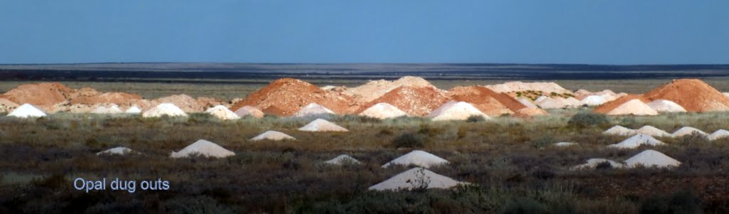
Coober Pedy itself is poke-marked with dug out for Opals, some might consider it an eyesore, but it has a beauty of its own, you can make your own judgement when looking at the pics.


Other than the ubiquitous Opal Galleries, we toured a few underground homes and local mines.  None demonstrates the tough characters of the locals more than Fay's underground home. It was hand excavated by Fay and her two companions, thirty odd years ago, she's now nearly 90.  The home boasts 3 beautifully appointed bedrooms and an indoor swimming pool as well.


The landscapes surrounding Coober Pedy is full of arid deserts, with wonderful colours, the Breakaways is renown for its beauty at dusk.

The Breakaways near Coober Pedy


The Painted Deserts
After a full day at Coober Pedy, we continued our trip north eastwards towards Oodnadatta, but not before we filled our fuel tanks and two extra 20L jerry cans as fuel supplies ahead could be very expensive. The drive through the awesome Painted Desert,unlike the previous few days, is distinctly lonesome, not another car to be seen for the most parts.  Other vehicles can be easily discerned by the raised dust cloud a long way off, but none could be seen today.


We reached Oodanadatta township, other than being the self proclaimed Hottest Driest Town of Australia, its iconic Pink Roadhouse is well known to 4x4 trippers.


Here is a video about it being for sale http://au.tv.yahoo.com/sunrise/video/-/watch/28713482/

There are a couple of International helpers working there ( a Canadian and a British, from memory ) when we walked in, but apparently we were the only wayfarers staying there that night, save a school inspector from Adelaide, whom we met at the camp site. He was to inspect the local school just behind the fence, over the next couple of days. Although it is a very small remote town boasting a population of 200+, half of them aborigines, but it does have a school, recreation facilities and other basic facilities.  Here is the link to the schools' web site http://www.oodnadattaab.sa.edu.au/

The next morning, we unloaded the jerry cans, and siphoned the fuel into the main tanks with fire extinguishers by the side. It turned out to be quite a easy job after working out the tricks of priming the simple "jiggle" siphon.


After sorting out the camping permits for Dalhousie Springs, our next stop in the northeastern direction, in the direction of the iconic Simpson Desert, we bade goodbye to the friendly staff at the Pink Roadhouse, and the few Coke drinking aborigine elders.

Unwittingly, we were actually following the Old Ghan Railway line ruins, the Adelaide - Alice Spring service, over the last week or so.  Our route had covered Marree, Coward Springs, William Creeks, and now Oodnadatta along the way.  Later that day, we were chewing our lunch by another one of the abandoned stations, at Pedirka.


Dalhousie Springs is a popular camp site on the main track to/from Simpsons Desert, formed by over 60 natural cartesian springs.  When we arrived in early afternoon, there were already quite a few campers set up and were horsing playing in the springs.  But the springs were so big, there is room for everyone, as it turned out, by late afternoon, few people were around, and we had the springs all to ourselves.  So was the next morning.


On waking the next morning, for the life of me, I could not find one of the slippers that I left outside the tent, and I could not see how any of the other campers would be interested in one of  my non-Armani slippers, intriguing indeed.  When I asked a resident Ranger who happened  to drive pass, about what could it be, he just smiled and said, "dingos like chewy things!".... puzzle solved.

As we pushed further north, it was again another lonely day.  Sections of the tracks feature sharp rocks, the landscape is very much Mars like, hot, dried and god forsaken.  Remembering the poor bloke we met in Coober Pedy who had to wait for a week to get his shredded tyres ( $400/piece) replaced after coming through this way, I took special care, whatever that means!!


We had a small rest at the famed Mt Dare Pub, the only drinking hole and fuel stop for those heading into the Simpson Desert, and quite a few ended back here, rescued by the able Mt Dare staff, and a few thousands dollars lighter. 


To go head long into the Simpson Desert is not to be taken lightly. For starter, with a petrol car like mine, I'll need to carry at least 8 jerry cans of fuel on the roof, plus 60L of water, to crest those 1100 sand dunes stretched over 800Km, for 5 days.  The only good news is, it is a well travelled track, and it is "busy", relatively speaking.


We crossed into Northern Territories soon after leaving Mt Dare, it was quite an anti-climax, just a nondescript rocky track with a cattle grid, no fan fare, no quarantine station, no nothing !!!!!!!! Boring!!  With a small sign, if one is not looking, one would miss it.  It is not unlike some of the State crossings in the US, but there are the busy street scenes, not emptiness, that mask the state borders, e.g. crossing from Massachusetts into Rhone Island, is totally nondescript.

After passing Finke, on our way to the Lambert Geographical Center of Australia, we ran into a couple of cars, one has a broken axle, on their way to Birdsville ( Queensland side of the Simpson Desert ) for the famous Birdsville Racing Carnival. Unfortunately the broken axle meant, it had to be towed 140 Km away, but it is better to have it broken here, than inside the Desert.  It is the other 80 series that got my attention, also with a petol engine, the bloke told me the 8 jerry cans of petol on the roof rack are all he needed for the numerous times he crossed the desert, in fact, after the races, he'll be crossing the desert back this way. Talking about experience...he's got it. By the way, for his poor mate who's got the broken axle, the tow truck won't be turning up for another 6 hours at least, and he'll keep him company in the meantime.

We reached the Geo-Center after navigating through a maze of soft sandy tracks, yap, here it is, with the Australian flag fluttering, I nearly starting singing Advance Australia Fair, but couldn't remember the lyrics..........!  Australia is finely balance about this point, so when I jumped down from the marker,  I have to be extra careful, lest I tipped Australia into one of the oceans, ever so slightly!!!!!!

The Center of Australia


We reached back near civilisation at the Kulgera Roadhouse on the Stuart Highway and settled into a windy night of camping, well before sunset, and saw the tow truck leaving to pickup the broken axle car we met early in the afternoon.

Please enjoy the photos via the link below...

You are invited to view David's photo album: 2011 Outback trip ( Geo Center )
2011 Outback trip ( Geo Center )
Aug 28, 2011
by David
If you are having problems viewing this email, copy and paste the following into your browser:
https://picasaweb.google.com/lh/sredir?uname=Australia.dt&target=ALBUM&id=5793466055250732145&authkey=Gv1sRgCPmmm-rXuc-P1QE&feat=email
To share your photos or receive notification when your friends share photos, get your own free Picasa Web Albums account.